

The best places to hike in Switzerland span Zermatt, Jungfrau, Engadin, and Ticino.
I have spent seasons on these trails, from dawn at Riffelsee to long days in the Alpstein. This guide breaks down the best places to hike in Switzerland, with clear routes, transit tips, and safety notes. You will get simple steps, expert picks, and tested advice. Read on to plan a trip you will love.
What makes hiking in Switzerland special
Switzerland sets a high bar for trail care and signs. Yellow signs mark hiking paths. White-red-white marks mountain routes. White-blue-white marks alpine routes. Trains and lifts link most trailheads, so you spend more time on the path and less time in transit.
Waymarking is exact. Distances and times are clear. Maps match the ground. The trails pass lakes, glaciers, meadows, and stone hamlets. Huts and farm cafés make food easy. You can do a world-class loop in half a day.
I hike here each year. The predictability and variety are rare. It is why many of the best places to hike in Switzerland work for first timers and experts alike.

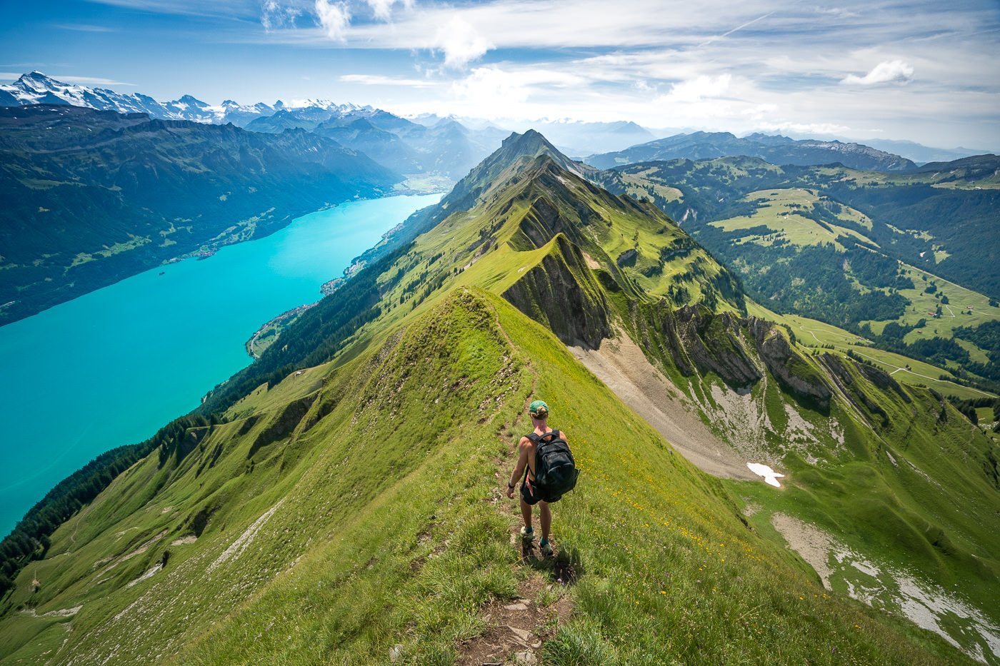
Best places to hike in Switzerland: top regions and signature trails
Below are the regions I return to most. Each one earns a spot among the best places to hike in Switzerland. Pick a base, then stack two or three trails for a great week.
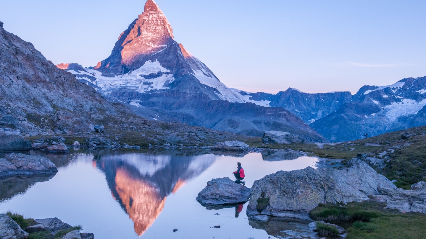
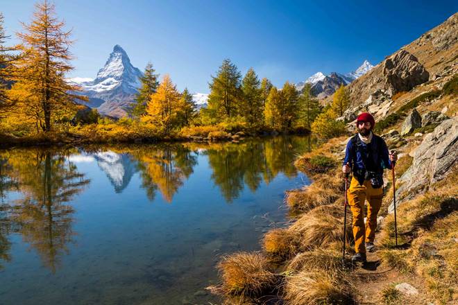
Zermatt and the Matterhorn
Zermatt is the postcard. It also has paths for all levels. Watch lift times here. Late starts and long photo stops can make you miss the last ride down.
- Five Lakes Walk, 5-Seenweg. Easy loop with Matterhorn views and lake mirrors (9 km, 3 h, easy).
- Hörnlihütte Trail. Reach the Matterhorn base hut from Schwarzsee (8 km round trip, 4–5 h, moderate).
- Gornergrat Ridge to Riffelsee. Peak-to-lake path with high views of the Gorner Glacier (6–8 km, 2–3 h, easy to moderate).
Jungfrau Region: Grindelwald, Wengen, Mürren, Lauterbrunnen
This valley hosts some of the best places to hike in Switzerland for views and simple access. Trains and lifts link each village.
- Eiger Trail. Walk below the Eiger’s north face from Eigergletscher to Alpiglen (6 km, 2 h, easy to moderate).
- Männlichen Panoramaweg. Wide views to Kleine Scheidegg with child-friendly grade (4.4 km, 1.5 h, easy).
- Schynige Platte to First. Big ridge day with lakes and peaks all day (16 km, 6–7 h, hard).
Personal note: A storm rolled in fast on my Schynige day. I cut the ridge short at Faulhorn. Watch the sky and build a Plan B.
Engadin St. Moritz and the Upper Inn Valley
Dry air, wide spaces, and larch forests glow in fall. This is one of the best places to hike in Switzerland for calm trails and stable weather.
- Muottas Muragl Panorama. Balcony path above the lakes of St. Moritz (5–8 km, 2–3 h, easy).
- Val Roseg. Flat valley walk to a glacier café with cake worth the effort (14 km round trip, 4 h, easy).
- Via Engiadina stages. Pick a gentle balcony stage between villages (varies, moderate).
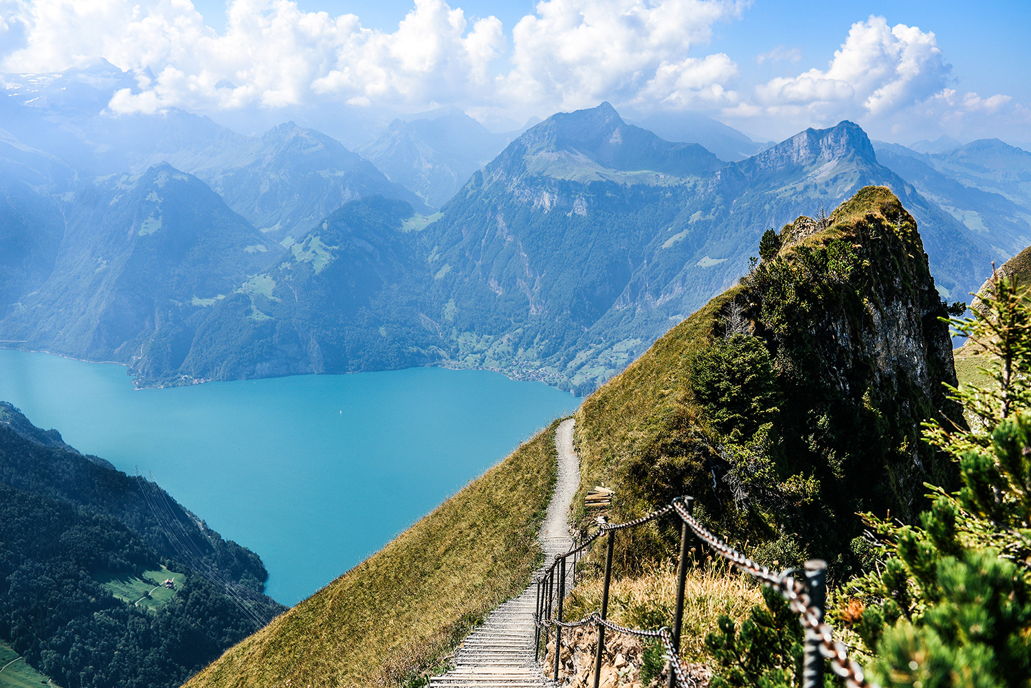
Appenzell and the Alpstein
Sharp limestone, green pastures, and cliff inns. Trails can be steep and exposed. Check your head for heights.
- Seealpsee and Äscher. Famous cliff inn loop from Ebenalp (8–10 km, 3–4 h, moderate).
- Saxer Lücke and Fälensee. Iconic notch view and lake backdrop (12–14 km, 5–6 h, hard).
- Schäfler Ridge. Short, steep, and airy with big drama (6–8 km, 3–4 h, hard).
Lake Oeschinen, Kandersteg
Blue water under huge walls. Family paths ring the lake. The higher loop is my pick for photos.
- Oeschinensee Shore Path. Flat sections and boats in summer (3–6 km, 1–2 h, easy).
- Heuberg Panorama Loop. The classic balcony route above the lake (8–10 km, 3–4 h, moderate).
- Fründenhütte. Steep, exposed, and for fit hikers only (12 km, 5–6 h, hard).
Aletsch Arena and the Great Aletsch Glacier
The longest glacier in the Alps. This area ranks among the best places to hike in Switzerland for glacier views without ropes.
- Moosfluh to Bettmerhorn. Balcony path over ice waves (10 km, 3–4 h, moderate).
- Bettmersee loop. Family-friendly stroll with swim spots (3–5 km, 1–2 h, easy).
- Eggishorn viewpoints. Short walks to huge vistas (1–3 km, 1 h, easy).
Ticino: Verzasca, Bavona, and the Tamaro–Lema ridge
Granite pools, stone bridges, and chestnut woods. The light feels Mediterranean. Summer swims are a treat.
- Lavertezzo to Brione in Val Verzasca. River path past emerald pools (8–12 km, 3–4 h, easy to moderate).
- Val Bavona hamlets. Short walks past stone barns and waterfalls (varies, easy).
- Monte Tamaro to Monte Lema. A classic ridge with lake views on both sides (13 km, 5–6 h, hard).
Lavaux Vineyards above Lake Geneva
Gentle terraces, boats, and wine stops. It is one of the best places to hike in Switzerland for an easy day.
- Lutry to Saint-Saphorin. Train-linked sections with village cafés (10–12 km, 3–4 h, easy).
- Chexbres loops. Short circuits with lake lookouts (3–6 km, 1–2 h, easy).
Verbier and Val de Bagnes
Wild side valleys and blue lakes. Fewer crowds than Zermatt.
- Lac de Louvie from Fionnay. A steep climb to a perfect hut by a lake (12 km, 5–6 h, hard).
- Sentier des Chamois. Narrow traverse that often lives up to the name (8–10 km, 3–4 h, moderate).
Swiss National Park, Zernez
Pristine, protected, and strict rules. No dogs, no shortcuts, stay on trail. Wildlife is the star.
- Val Trupchun. Arguably the best wildlife hike in the country (14–19 km, 4–6 h, moderate).
- Fuorn Pass area loops. Larch and rock paths with deep quiet (varies, moderate).
These are, in my view, the best places to hike in Switzerland for a first, second, or tenth trip. Mix a high-view ridge day with a gentle lake day. Your legs and camera will thank you.

Best time to hike and seasonal tips
Late June to mid October is prime. Snow melts by late June at mid levels. High routes hold snow longer. October brings gold larch in the Engadin and quiet paths.
- Spring, May to mid June. Low valleys and vineyard paths shine. High routes are often snowed in.
- Summer, late June to early September. Most lifts run. Wildflowers peak. Start early for cool air and space.
- Fall, mid September to late October. Clear light and stable days. Some lifts stop by late September. Check dates.
- Winter hiking. Many resorts mark groomed winter trails. Use spikes if it is icy.
I like late September. The weather is steady. Crowds fade. You get crisp views on clear days. It is a smart time to visit the best places to hike in Switzerland.

How to plan routes and use Swiss transport
Switzerland makes planning simple. Trains and postbuses reach most trailheads. Lifts save big climbs.
- Use national rail apps to link train, bus, and lake boats.
- Check lift times. Last rides can be early in shoulder season.
- Download SwitzerlandMobility or the national topo app. Save maps offline.
- Build A to B hikes. Start high, end low. Your knees will thank you.
- Consider passes. Half Fare Card, Saver Day Pass, or regional passes can cut costs.
I plan each day with a main route and a short fallback. Weather can turn fast. This habit has saved me more than once.

Safety, trail grades, and simple mountain etiquette
Know the signs and grades. Match them to your skills.
- Yellow signs, Wanderweg. Hiking paths, often wide. T1–T2 grade.
- White-red-white. Mountain paths with rocks and drops. T2–T4 grade.
- White-blue-white. Alpine routes with exposure. T4–T6 grade. For experts only.
Core tips that work anywhere in the best places to hike in Switzerland:
- Check the forecast on the day. Storms build fast near ridges.
- Carry layers, a shell, water, and a small first aid kit.
- Note the last lift or bus. Set an alarm on your watch.
- Pass cows calm and wide. Close gates. Give way to uphill hikers.
- If the path feels wrong, stop and check the last sign.
I once met black ice on an easy yellow path at dawn. Poles and slow steps kept me upright. Easy does not mean risk-free.
Gear checklist and smart tech
You do not need much. You do need the right basics.
- Footwear. Trail runners or light boots with good grip.
- Layers. Wicking base, warm mid, packable shell.
- Sun care. Hat, sunglasses, SPF 30+.
- Poles. Help on steep downs and in loose gravel.
- Water and snacks. Use huts and fountains to refill.
- Phone and offline maps. Add a small power bank.
- Apps. SwitzerlandMobility, SwissTopo, and MeteoSwiss are my core trio.
Pack light. You will enjoy the best places to hike in Switzerland more when your pack is under 6–8 lb.
Multi-day treks that earn the views
If you want a longer goal, these routes are proven. Book huts early in peak weeks.
- Via Alpina, Green Route. From Sargans to Montreux over passes and meadows (2–14 days, moderate to hard).
- Walker’s Haute Route, Swiss stages. Mountain passes between Arolla, Zinal, and Zermatt (choose 3–7 days, hard).
- Jura Crest Trail. Quiet ridge days with wide views to the Alps (4–10 days, easy to moderate).
- Via Engiadina. Balcony paths across the Engadin with sun and space (3–7 days, moderate).
Huts include dinner and breakfast. Cash helps in remote huts. Ear plugs help too.
Family-friendly and accessible hikes
You can see a lot with little effort. These are some of the best places to hike in Switzerland for families and relaxed days.
- Männlichen Panoramaweg. Wide track, pushchair-friendly with care (4.4 km, easy).
- Lake Lucerne, Weg der Schweiz sections. Pick short lakeside legs with boat links (2–8 km, easy).
- Bettmeralp village loops. Flat walks with glacier views and play spots (2–5 km, easy).
- Zermatt Sunnegga to Leisee. Short walk to a swim lake with a view (1–3 km, easy).
Add a lift ride and a picnic. Aim for morning starts. Nap time on the train home is real.

Photography spots and golden hours
Soft light makes the Alps glow. Plan your day around sunrise or sunset when you can.
- Riffelsee, Zermatt. Sunrise mirror of the Matterhorn is hard to beat.
- Bachalpsee, Grindelwald. Evening calm can glass the lake.
- Lavaux terraces. Late light paints lines across the vines.
- Moosfluh, Aletsch. Side light shows the ice waves in full depth.
- Saxer Lücke. Morning light hits the ridge like a stage.
Bring a light tripod, a cloth for lens mist, and spare batteries. The best places to hike in Switzerland reward patience.
Budget, passes, and mountain huts
Costs add up. Smart passes and picnics help.
- Passes. Half Fare Card cuts most fares by half. Saver Day Pass can be a steal on long days.
- Regional deals. Jungfrau, Tell-Pass, and others are good if you ride lifts a lot.
- Food. Pick up lunch at Coop or Migros. Refill bottles at signed fountains.
- Huts. Book early. Half-board is the norm. Pack a hut liner.
Set a daily plan. One paid lift, one big hike, one hut stop. That gives you a rich day without stress. It also keeps your focus on the best places to hike in Switzerland.
Frequently asked questions of best places to hike in switzerland
What are the best places to hike in Switzerland for first timers?
Start with Zermatt’s Five Lakes Walk, Männlichen Panoramaweg, and Lavaux. They are scenic, signed, and easy to reach by train and lift.
When is the best month to visit the best places to hike in Switzerland?
Late June to mid September is ideal for high routes. Late September to early October is great for clear air and fewer crowds.
Do I need special gear for the best places to hike in Switzerland?
No, but wear good shoes and bring layers, sun care, water, and a shell. Poles help on steep downs and loose paths.
Are the best places to hike in Switzerland safe for kids?
Yes, many are. Pick yellow-signed paths like Männlichen, Bettmeralp loops, and lakeside trails with clear footing.
How do I use public transport to reach the best places to hike in Switzerland?
Use the national rail app to plan train and bus links. Check lift timetables and buy passes if you plan many rides.
Can I hike the best places to hike in Switzerland in May?
Low valleys and vineyard paths work in May, but high routes often hold snow. Check local reports and be flexible.
Conclusion
Switzerland shines because it blends wild views with smooth logistics and clear signs. Pick two or three regions, choose a mix of easy and moderate routes, and learn the signs. You will see why these are the best places to hike in Switzerland.
Book a base, check lift times, and set your first trail. If this guide helped, share it, subscribe for more trip plans, or ask a question so I can fine-tune your route.


